

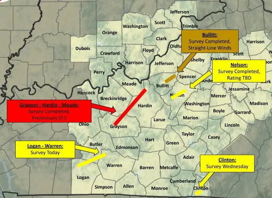
The National Weather (NWS) says an EF-1 tornado struck Grayson County on Sunday night.
The twister, with a peak wind speed of 110 miles per hour, was first spotted by Caneyville Fire Chief Brian Pharris near the Valero in the 500 block of Morgantown Street (Hwy 79) at 10:03 p.m., according to the NWS.
The tornado, which was approximately 100 yards wide, traveled northeast where it inflicted damage on Hopewell Road, Stones Chapel Road, Clifty Church Drive, Lilac Road, and Lewis School Road as the twister left Grayson County and entered southwest Hardin County.
The path of the tornado was 43.75 miles, as the twister dissipated in northwest Hardin County near Ft. Knox.
Straight-line winds reaching up to 70 miles per hour inflicted damage in Leitchfield, as well.
The tornado caused extensive damage in Grayson County and killed three cows on Clifty Church Drive.
The National Weather Service’s Public Information Statement on the tornado path and damage inflicted
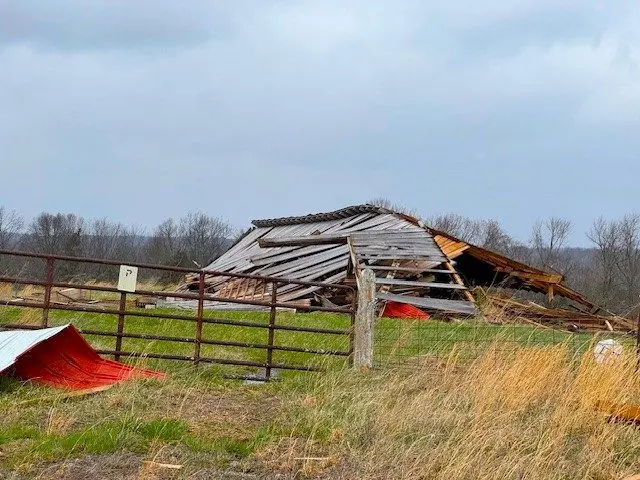
The first report of the tornado came from Caneyville Fire Department of a tornado touchdown observed north of Caneyville. Damage was observed north of Caneyville with tree damage near Highway 79 to near Chronicle Lee Road. The tornado continued along Hopewell Road in Grayson County near the Caneyville and Millwood areas. Several farm outbuildings had the roof peeled off, with one farm having wood planks from the barn damage thrusted into the nearby residence. The residence also had shingle damage. Max winds of 100 mph were estimated in this location.
The tornado continued to the northeast across Jones Hill and highway 54 to Stones Chapel Road. Several farm outbuildings and tree damage was observed, including roof material lofted into nearby trees. The tornado continued across Clifty Church Drive where a farm had damage to several outbuildings where rooftops were destroyed. At this location, 3 head of cattle were fatally injured resulting in roughly $7K in damages. Debris from the farm was lofted into the treeline about a tenth of a mile from the property.
The tornado continued to the northeast toward Lilac Road where several farm outbuildings on a hill top were completely destroyed. Wood planks were driven into the ground in several directions and debris was lofted over the nearby hill. Significant tree damage was observed here as well. Max estimated wind speeds of 110 mph were observed here.
The tornado continued to the northeast toward Brandenburg Road where trees were uprooted. The tornado continued across Rough River Lake and into Hardin county near Hardin Springs where several trees were uprooted and snapped. The tornado continued to the northeast near Pierce Mill and Garfield. Significant damage occurred to a home near Pierce Mill Road, where a portion of the roof was taken from the home above the garage and living space below. Mud splatter occurred to the front of the home at this location, and a wood plank was thrown backward into the roof above the living room. Several wood pieces were impaled into the ground at the property. The tornado continued near Vertrees and toward Four Corners in Hardin County, where outbuilding damage was observed and several trees in a tree line were snapped. Max winds were estimated to be near 100 mph at this location.
The tornado continued towards Berrytown Road where several locations had significant tree and farm outbuilding damage. Several barns lost their roofs with wood plank impalements nearby. Winds were estimated to be around 110 mph at this location.
The tornado continued across Rineyville Road and Joe Prather Highway near Flaherty. The Meade County Bank had sign damage and some minor roof damage. Damage was observed to trees and some houses along Camelot Drive and Rolling Hills Road. The tornado continued across fields and did extensive damage to a farm beside Fort Avenue. Multiple farm buildings were significantly damaged with roofs lofted across Fort Avenue into a field.
The tornado continued across Highway 31 onto Fort Knox where an advanced spotter reported damage to trees on base. Up to that point, the storm had been taking a hard left to the rest of the storm motion, and this last damage point was more in line with storm motion. Beyond this point, there was no observable or reported damage.
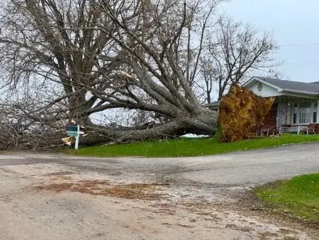
(Hedline photo: A large uprooted tree on Stones Chapel Road)
By Ken Howlett, News Director
Contact Ken at ken@k105.com