


Tornadoes touched down in neighboring Ohio and Hart counties during Monday night/Tuesday morning’s severe weather event.
The National Weather Service (NWS) said an EF-1 twister touched down northeast of Hartford and carried with it maximum sustained winds of nearly 100 miles per hour.
Sheriff Adam Wright told news outlets that damage has been reported on Mill Run Lane and near I-69 north, including a roof stripped off a home.
No injuries have been reported.
An EF-0 tornado touched down near Millerstown in Hart County. That twister had estimated maximum wind speeds of up to 80 mph.
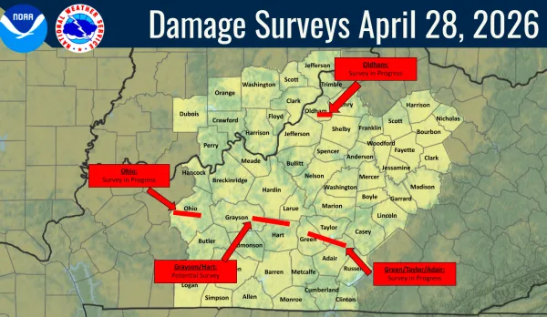
Grayson Co. impact
There remains a possibility that NWS storm surveyors may arrive in Grayson County, as the agency currently states a “potential survey” is possible. The county was under a Tornado Warning from 1:22 a.m. and 1:32 a.m. Tuesday. Initially, the warning was to be in affect until 1:45 a.m.
The county woke up to trees crossing a few roadways in the Caneyville and Clarkson areas, as well as on Sinks Road.
There were, at peak outage, approximately 300 electric customers without power in the area of Beaver Dam Road (Hwy 62) between Leitchfield and Millwood on Tuesday morning.
If anyone in Grayson County has storm-related damage, send photos and the address where the damage occurred to Grayson County Emergency Management at graysonemergency@gmail.com.
Green Co.
Greensburg, in Green County, experienced what NWS storm assessors describe as straight-line wind damage, with wind speeds reaching up to 80 mph. An NWS damage survey is ongoing.
Ongoing damage surveys are taking place in Adair and Taylor counties.
Severe thunderstorms possible Tuesday night
While no official watches or warnings have yet been issued (as of 2:15 p.m.), the NWS has “medium confidence” that severe weather could impact Grayson County Tuesday night, including strong thunderstorms, large hail and damaging winds. There is a “small chance” of a tornado, according to the NWS.
The severe weather is expected to arrive around 8:00 p.m.
By Ken Howlett, News Director
Contact Ken at ken@k105.com